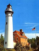
Sturgeon Bay Canal Light
Appearance
 | |
 | |
| Location | Sturgeon Bay, Wisconsin |
|---|---|
| Coordinates | 44°47′42.038″N 87°18′48.03″W / 44.79501056°N 87.3133417°W[1][2] |
| Tower | |
| Constructed | 1899 |
| Foundation | Concrete |
| Construction | Steel / Iron |
| Height | 98 feet (30 m) |
| Shape | Cylindrical |
| Heritage | National Register of Historic Places listed place |
| Light | |
| First lit | 1899 |
| Focal height | 32 m (105 ft) |
| Lens | Second order Fresnel lens |
| Range | 17 nautical miles (31 km; 20 mi)[1] |
| Characteristic | Red, flashing 10 s[1] |
Sturgeon Bay Canal Lighthouse | |
| Area | 0.3 acres (0.12 ha) |
| Built | 1899 |
| MPS | U.S. Coast Guard Lighthouses and Light Stations on the Great Lakes TR (Archived October 17, 2012) |
| NRHP reference No. | 84003666[3] |
| Added to NRHP | July 19, 1984 |
The Sturgeon Bay Canal lighthouse is a lighthouse located at the Coast Guard station near Sturgeon Bay in Door County, Wisconsin.
Situated on the east side of the south entrance to the Sturgeon Bay Ship Canal, it was listed in the National Register of Historic Places in 1984, as the Sturgeon Bay Canal Lighthouse.[3] The lighthouse originally was constructed in 1899; instability forced the addition of steel bracing in 1903. It is similar to the reinforced Devils Island Lighthouse.
There are two lighthouses at this location, the other being the Sturgeon Bay Canal North Pierhead Light.
Gallery
[edit]Notes
[edit]Wikimedia Commons has media related to Sturgeon Bay Canal Station Light.
- ^ a b c d Light List, Volume VII, Great Lakes (PDF). Light List. United States Coast Guard. 2014.
- ^ Sturgeon Bay Canal Light in Lighthouse Resources: Historic Lighthouses & Light Stations, United States Coast Guard, October 18, 2019
- ^ a b Sturgeon Bay Canal Lighthouse, npgallery.nps.gov
References
[edit]- "Historic Light Station Information and Photography: Wisconsin". United States Coast Guard Historian's Office. Archived from the original on May 1, 2017.
- Light List, Volume VII, Great Lakes (PDF). Light List. United States Coast Guard.
Further reading
[edit]- Havighurst, Walter (1943) The Long Ships Passing: The Story of the Great Lakes, Macmillan Publishers.
- Oleszewski, Wes, Great Lakes Lighthouses, American and Canadian: A Comprehensive Directory/Guide to Great Lakes Lighthouses, (Gwinn, Michigan: Avery Color Studios, Inc., 1998) ISBN 0-932212-98-0.
- Pepper, Terry. "Seeing the Light: Lighthouses on the western Great Lakes". Archived from the original on April 2, 2022.
- Sapulski, Wayne S., (2001) Lighthouses of Lake Michigan: Past and Present (Paperback) (Fowlerville: Wilderness Adventure Books) ISBN 0-923568-47-6; ISBN 978-0-923568-47-4.
- Wright, Larry and Wright, Patricia, Great Lakes Lighthouses Encyclopedia Hardback (Erin: Boston Mills Press, 2006) ISBN 1-55046-399-3.
External links
[edit]- Door County Lighthouses, Door County Marine Museum.
- Pepper, Terry, Seeing the light, Sturgeon Bay Canal Lighthouse (Archived October 24, 2021)
- Lighthouse friends article
- NPS Inventory of Historic Light Stations - Wisconsin (Archived October 19, 2006)


